Boundary Waters Map with Entry Points
The Boundary Waters BWCA map illustrates where River Point Outfitting Co. “Ely Outfitters™” is located in reference to the Ely area entry points into the Boundary Waters Canoe Area of northern Minnesota.
The Boundary Waters map shows the Boundary Waters (BWCAW) and its relationship to Canada’s Quetico Provincial Park. Quetico Park is shown in the top of the map in yellow.
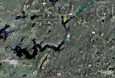
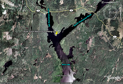
River Point’s private lakefront peninsula is shown in the header image of this page with River Point in the foreground and the South Kawishiwi River on the east and west sides of the property. Off the point to the south is beautiful 20 mile-long Birch Lake, which lies outside of the protected BWCA.
SERVICING ALL ELY AREA ENTRY POINTS
River Point Outfitting Co. services all entry points into the 1.1 million acre Boundary Waters Canoe Area within the northern third of the Superior National Forest in Minnesota. On the Boundary Waters map the BWCA is shown in green. River Point’s location is just south of entry point #32, which is the South Kawishiwi River. This river provides a natural waterway to the BWCA and is the east border of River Point’s mile long wilderness peninsula.
PADDLE THE QUIET SIDE® ELYOUTFITTERS™
River Point is the only outfitter with direct paddle access to and from eleven different entry points in the Ely/Isabella area. You may choose to paddle back to RPO with a gentle downstream current on your last day from entry points such as the South Kawishwi River, Little Gabbro Lake, North Kawishwi River, Lake One, Farm Lake, Snake River, Little Isabella River, Island River, Isabella Lake, Kawishiwi Lake and more.
River Point’s incredible lake location makes it your best choice for your Paddle the Quiet Side® canoe trip.
This unique water-based location as shown on the Boundary Waters map also allows for the flexibility in servicing all Ely area entrance points, such as Indian Sioux, Moose River Portage North, Mudro Lake, Snowbank Lake, Fall Lake, Wood Lake and more.
If you are a first time paddler to the BWCA and have no idea which entry point to select, or a seasoned paddler, River Point’s strategic location will be a great asset to your canoe trip.
The famous wilderness of the Boundary Waters BWCA with its interconnected waterways and deep green pine forests is unlike any other wilderness area in the world. Let us help you plan your first BWCA adventure, or your next one. We’re here to help select an entry point that best serves what your interests are, and one that meets your expectations for a successful and happy paddling experience.
Reference a detailed River Point map with links to various parts of the property, such as the Canoe Outfitting Base, lakefront Bunkhouses, and swim rafts. There is also a different aerial view of the peninsula in relation to the South Kawishiwi River and Birch Lake on River Point Map.
“One touch of nature makes the whole world kin.” -William Shakespeare


